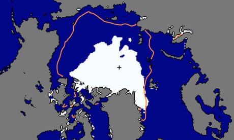
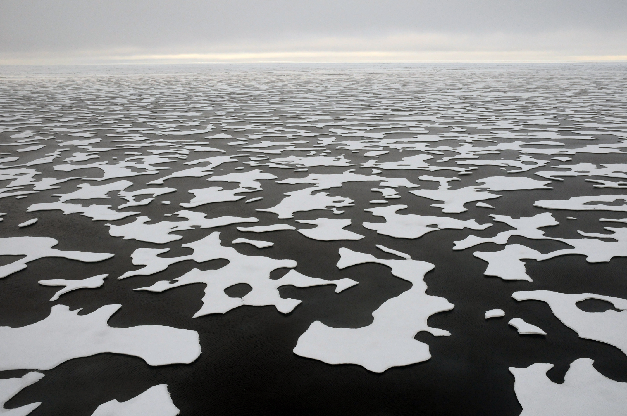
A NASA SATELLITE IMAGE, SHOWS HOW A FORMER ICE LAND, HAS DISSAPEARED
The Arctic Ocean will be Ice-Free by 2045
REAL TIME MELTING
Each American's carbon emissions melt 500 square feet of Arctic sea ice every year
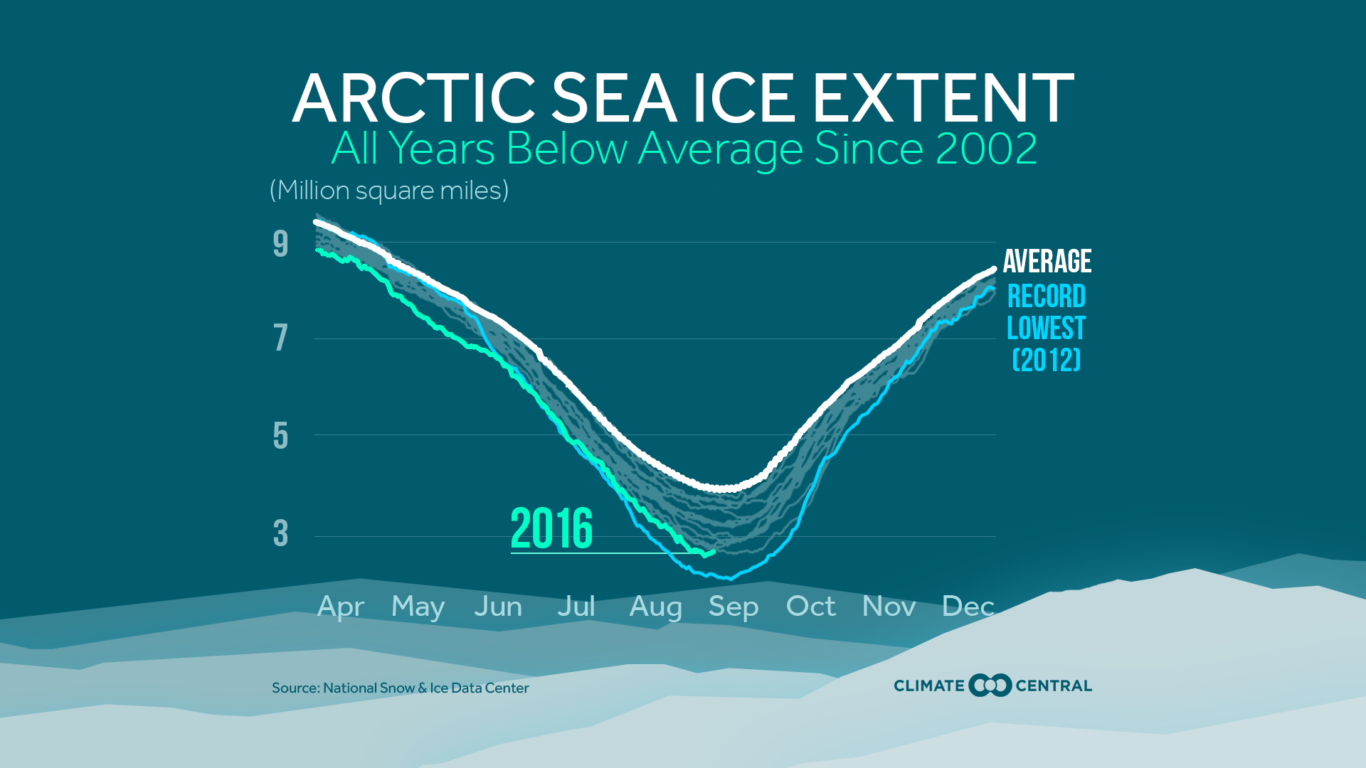
As governments convene in Marrakech, Morocco, for this year's meeting of the United Nations Framework Convention on Climate Change (UNFCCC), the impact of a changing climate continues to be felt several thousand miles to the north. This year's minimum Arctic sea ice extent tied with 2007 for the second-lowest on record, and its regrowth in fall and winter is proving to be sluggish. From Oct. 1 to 15, ice extent increased by less than one-third of the 1981-2010 average gain for that period; by Oct. 31, Arctic sea ice extent stood at 2.73 million square miles, the lowest extent in the satellite record for that date.
Meanwhile, a new study in the journal Science argues that computer models have been underestimating Arctic sea ice loss, and that the region could become effectively free of summer sea ice by 2045. In the study, Dirk Notz of the Max Planck institute for Meteorology in Hamburg, Germany and Julianne Stroeve of the National Snow and Ice Data Center in Boulder, Colo., compared annual human-caused greenhouse gas emissions with observations of September Arctic sea ice extent over the period 1968 to 2000. They found that the two elements had a strong linear relationship, to the extent that it was possible for them to calculate that every additional metric ton of carbon dioxide emitted into the atmosphere resulted in the loss of about 33 square feet of Arctic sea ice.
This enabled them to come up with a way of showing how individual actions contribute to changes in the Arctic. For example, they calculated that every seat on a flight from London to San Francisco comes at a cost of about 54 square feet of sea ice.
The annual carbon emissions of the average American would be enough to melt about 500 square feet-nearly 10 times as much as the average Indian, for example.
"So far, climate change has often felt like a rather abstract notion. But now, it is a global drama that regard the continuity of the life on Earth
The science 2016 results, allow us to overcome far beyond this blind perception
Scientist then used their discovery to look at the Arctic's future, and found that an additional 1,000 gigatons of carbon would be enough to reduce Arctic sea ice cover in September to below 386,000 square miles -which, given that that ice would be tucked into a few pockets such as northern Greenland, will effectively render the Arctic Ocean ice-free.
At present rates of CO2 emissions, which are around 35 gigatons per year, that scenario will unfold and totally irreversible by around 2045
The severe change that it implicates, due to the brake of the balance of the weight on the North Hemisphere, sooner or later, but in this Century without doubt, will even produce a dangerous movement of the Earth Axe, causing the most tremendous earthquakes, tsunamis and maremotos, that the present Civilization could ever register
They found that the extent of ice loss outpaced that in most computer models, because, Notz said, those models likely underestimate the amount of Arctic warming that is taking place. Measurements of air temperatures above the Arctic Ocean remain limited.

"Models are not perfect. And if we can use observations by ourselves to forecast when Arctic ice will go away, maybe that's in some ways much more realistic, regarding the inevitable extinction situation"
Even in 2007, when it was declared the maximum melting global alarm, marking already at that time as a climate disaster, the Greenland glacier was much bigger than nowadays.
EL GIGANTESCO GLACIAR DE GROENLANDIA,
EN VELOZ CAMINO A LA DESAPARICIÓN
El lamentable futuro de extinción de Groenlandia

En 1888 el gran explorador noruego Fridjot Nansen atravesó por primera vez las inmensas tierras de Groenlandia valiéndose solamente de su resistencia, su voluntad y un par de esquís que él mismo diseñó para la travesía.
Nansen fue un pionero en aplicar y adaptar las tradicionales técnicas esquimales a las modernas expediciones árticas, y abrió el camino a numerosos aventureros que durante las siguientes décadas siguieron la carrera por la conquista de los Polos.
Desde finales del Siglo XIX hasta las más recientes expediciones polares, los Museos de todo, el mundo albergan un extenso catálogo pictórico y fotográfico que forma parte de una de las aventuras más fascinantes de la Humanidad.
Sin embargo, este gigantesco archivo fotográfico puede sernos muy útil, no solo como memoria imborrable de aquellas épocas de exploración, sino para comprobar cómo el paso del tiempo ha tratado a esos gélidos parajes árticos.
El investigador danés Anders Bjørk junto a un equipo de conservadores e historiadores del Museo de Historia Natural de Dinamarca en Copenhague están desarrollando un proyecto realmente interesante:
Desempolvar casi doscientas mil fotografías antiguas del archivo de imágenes de la institución para estudiar cómo se han comportado los glaciares y las plataformas de hielo en Groenlandia desde el Siglo XIX

El calentamiento global está afectando especialmente a las zonas árticas, y solo en Groenlandia se están perdiendo aproximadamente 200 millones de toneladas de hielo cada año. Un hecho que debería preocuparnos puesto que si se derritiera todo el hielo que alberga la gran Isla, el nivel del mar podría subir hasta seis centímetros antes de finales de este siglo.
Por supuesto hacer predicciones y simulaciones de futuro es un campo realmente complicado; se necesita analizar mucha información y desafortunadamente tan solo contamos con datos de Satélites desde hace unos cuarenta años. Por esta razón, el trabajo de Museos como el de Dinamarca, está siendo de tanta utilidad para comprobar el cambio experimentado por los Glaciares durante los primeros años del Siglo pasado y realizar proyecciones más cercanas y fiables.

Además, el trabajo de archivo del equipo de historiadores de Anders Bjørk se está completando con la labor de investigadores daneses de las Universidades de Copenhague y Aarhus que llevan fotografiando Groenlandia desde 2010, buscando las mismas localizaciones y el mismo punto de vista que las fotografías de los años ’30 conservadas en el Museo.
Las composiciones que os ofrecemos en este artículo corresponden a fotografías tomadas en 1933 de diversos glaciares en Groenlandia, como el glaciar Mittivakkat o el de Tunu, comparadas con el estado actual del hielo en nuestros días.

La colección de imágenes de la década de 1930 incluye además unas 10.000 fotografías aéreas que se realizaron desde un hidroavión a 4.000 metros de altitud. Ahora, Björk y sus colegas están utilizando estas imágenes antiguas y las están combinando con las fotografías recientes sumadas a las observaciones satelitales, consiguiendo así un registro detallado de cómo han cambiado un total de 132 glaciares en Groenlandia en los últimos 80 años.
Los resultados son lamentables y confirman que cientos de Glaciares en Groenlandia, han disminuido de manera descomunal, la cantidad y el grosor de su hielo en el último Siglo, siendo este descenso mucho más pronunciado en las últimas dos décadas.



/cdn0.vox-cdn.com/uploads/chorus_asset/file/3521034/Screen_Shot_2015-03-19_at_3.57.24_PM.0.png)

No hay comentarios:
Publicar un comentario