
November 27th, 2018 – INDIA – In last few
years, Himachal Pradesh (HP) is witnessing increased frequency of earthquakes
up to 5 magnitude on the Richter scale, which has led to the fear of bigger
quakes hitting the state in future. While experts are claiming low intensity
quakes release seismic energy to avoid bigger earthquakes, unplanned
constructions, even on steep hills, has led to fear of widespread destruction
if a high magnitude earthquake hits the state.
In the past 90 years, 250 quakes
of magnitude 4 and more than 60 with a reading of 5 on the Richter scale have
rocked HP and adjoining states of Jammu and Kashmir (J&K) and Uttarakhand.
On Tuesday, a low intensity earthquake of magnitude 5 had hit Kullu, Chamba and
Lahaul-Spiti districts and its epicenter was between J&K and HP. Last
month, between June 4 and 6, four low intensity earthquakes had hit the state
and epicenter of all the quakes was between Chamba and
Lahaul-Spiti.
The areas falling in districts Chamba, Kangra, Mandi,
Kullu, Hamirpur and Bilaspur are very sensitive as they fall in the very high
damage risk seismic zone (Zone V), whereas the rest of the areas falls in high
damage risk zone (Zone IV).
According to D D Sharma of Himachal Pradesh
University, frequent occurrences of low intensity earthquakes are good because
they help in releasing the seismic energy and does not allow accumulation of
energy, which later results in earthquakes of bigger magnitude and intensity.
“It is said that a big earthquake revisits after a gap of 50 years and in
Kangra District for last 110 years no major earthquake has occurred.
It was in 1905 when 20,000 people were killed in
Kangra so threat of a major earthquake is more in that area,” he added.
Sharma said a study had shown that if an earthquake of bigger magnitude
takes place in Himachal during night hours, then it would kill 240,000 people
while during the morning hour casualty would be around 160,000.
An
assistant professor of geology at HPU’s regional centre at Dharamshala, Mukta,
said that after a major earthquake in 2005, whose epicenter was in Kashmir,
Himachal has been witnessing low intensity earthquakes at regular intervals.
“Last year in October-November around 7-8 low intensity earthquakes were
recorded in Dharamshala and Baijnath areas of Kangra district in a span of 3-4
days,” she said. Massive haphazard constructions in the hill towns of Shimla,
Dharamshala, Dalhousie and Kullu have made them prone to natural hazards like
earthquake.
In Shimla, construction has taken place on steep slopes. An
earthquake of 8 or above magnitude can turn the tourist town into rubbles as 14
major localities are situated on an average slope of 35 to 70 degrees with peak
population density of 2,000 to 3,000 per hectare, despite the fact that the
city falls under Seismic Zone IV
Anthör Zeît Geîst
AZ Earth Devastation Research
- - - - - - - - - - - - - - - - - - - - - - - - - - - - - - - - - - - - - - - - - - - - - - - - - - - - - - - - - - - - - - - - - - - - - -

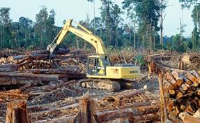
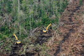
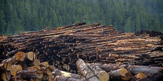
Los bosques ocupan actualmente unos 4.000 millones de Hectáreas, que representan en torno al 31% de la superficie del Planeta. Por otro lado, en los últimos diez años, el promedio anual de desaparición de los bosques, ha llegado a ser de más de 5,5 millones de Hectáreas anuales.


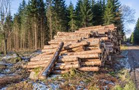

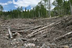
Según datos de la ONU, más de 1.650 millones de personas, dependen directamente de los bosques para vivir, ya que éstos, desempeñan un papel fundamental en la vida de las comunidades rurales, suministrando, entre otros recursos, madera, alimentos, forraje y medicinas.

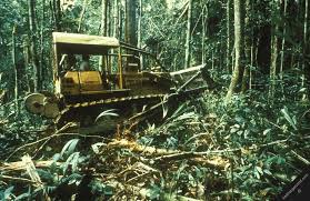
Como se explica en el documento "El futuro que Queremos", surgido de la Conferencia de las Naciones Unidas sobre el Desarrollo Sostenible Río+20:

"La amplia gama de productos y servicios que proporcionan los bosques, crean oportunidades para hacer frente a muchos de los problemas más acuciantes del desarrollo sostenible."
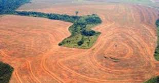
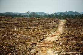
La desaparición de los Bosques para fines de este Siglo e inicios del Siglo XXII, implicará la desertificación masiva de todo el Planeta, con la consecuente hambruna global que diezmará a la mayor parte de la Humanidad.

